Trail alerts

Closed Breakneck Ridge station is closed

What to do instead Get off at Cold Spring for the southern trail, Beacon for the northern.

What to do instead Full notice

No trains stop here. Closed April 2025, being rebuilt as part of the Fjord Trail.

active From Mon, Apr 21, 12:00 AM, until further notice Source: Metro-North

← The trail

Trail section

Fjord Trail South — River Reach

Mile 0.0 – 2.1

Planned
TUE, AUG 11

River Reach closed for boardwalk works

Go via the Washburn and Cornish trails. Adds 25 minutes, steep, not step-free.

Tue, Aug 11, 6:00 AM–4:00 PM · HHFT

Trail information

ABA §1017.10

Length
2.11 mi · 11142 ft
Surface
Not yet decided
Tread width
Not yet decided
Running slope
1.4% typical 12.2% maximum
Where the slope figures come from, and how the section breaks down

92.8% of this section is at or below a 5% running slope. About 808 ft is steeper, reaching 12.2% at its worst. Modelled from USGS 3DEP elevation along the traced alignment — not measured on site.

Modelled from USGS 3DEP elevation, sampled every 25 m along the traced alignment. Terrain, not tread.

Slope figures modelled from USGS 3DEP elevation sampled at 25 m along the traced alignment. The trail is not built; these are terrain estimates, not as-built measurements.

Cross slope
Not yet decided
Step-free
Not assessed — not built
What step-free means here, and why it is not assessed

Nothing on this section has been built, so nothing has been measured on the ground. A step-free answer needs a finished tread, a finished cross slope and a finished surface, and none of the three exists yet.

Walking time
About 58 min
Opens
2027
Assessed
Never — the trail is not built

Alignment traced from NYS OPRHP / HHFT Final GEIS (January 2026), Figures II-1a–c — indicative, not survey data.

Elevation

-2 to 40 ft

Modelled from USGS 3DEP · not surveyed

How much of this section is modelled at or below a 5% running slope
92.8% of the modelled length sits at or below a 5% running slope. The steepest modelled grade is 9.1%.

  • accessible — 10343 ft
  • not accessible — 82 ft
  • ramp equivalent — 566 ft
  • steep 10ft max — 79 ft
  • steep 30ft max — 82 ft

Where it sits

±15–25 m

The Fjord Trail corridor, Cold Spring to Beacon A schematic map of the Hudson Highlands Fjord Trail corridor between Cold Spring and Beacon, showing Main Trail, Connectors, Meanders, Trailheads. 7.8 miles end to end. The trail list at /map/ carries the same features as text. Dockside Park Little Stony Point
Fjord Trail South — River Reach, drawn heavier, with the corridor around it. Indicative alignment — not survey data. Traced from the published FGEIS figures (January 2026) to about ±15–25 m. The trail is not built and the alignment is not final. Open the interactive map with Main Trail, Connectors, Meanders, Trailheads switched on · Read the same features as a list

Join it at

3 places

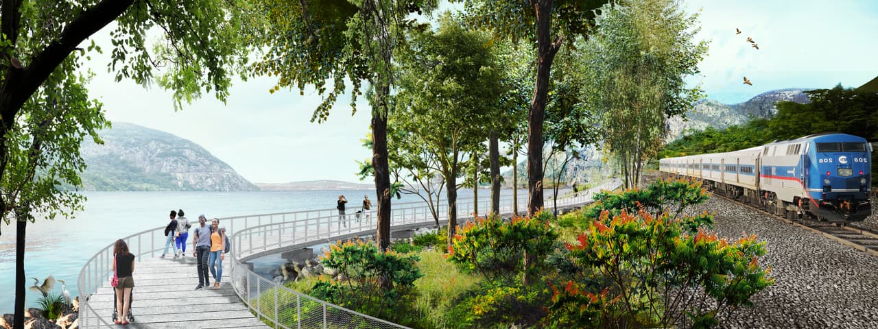
Wide artist's rendering of the proposed shoreline boardwalk: a timber deck carried out over the water on the left with walkers and cyclists on it, orange wildflowers planted along the landward edge, and a Metro-North train running past on the tracks immediately to the right.
Artist's rendering — not a photograph · SCAPE Artist's rendering by SCAPE — the proposed shoreline trail beside the Hudson Line. Not built.