Trail alerts

Closed Breakneck Ridge station is closed

What to do instead Get off at Cold Spring for the southern trail, Beacon for the northern.

What to do instead Full notice

No trains stop here. Closed April 2025, being rebuilt as part of the Fjord Trail.

active From Mon, Apr 21, 12:00 AM, until further notice Source: Metro-North

The Fjord Trail — 7.8 miles, Cold Spring to Beacon

62 places and trail sections along 7.8 miles. Closures checked at 1:32 pm on 10 August 2026.

Map

The map needs JavaScript and WebGL.

Every place on it is listed below, in order from Cold Spring to Beacon.

Indicative alignment

✕ 1 closed

  • 7.8 Corridor miles
  • 0 Open now
  • 11 Sections
  • 0.9 Mi not drawn

Now

MON, AUG 10, 1:32 PM

Closed

River Reach closed for boardwalk works

Shoreline between Little Stony Point and Dockside Park, Tuesday 6am–4pm, while boardwalk sections are lifted in.

Instead Go via the Washburn and Cornish trails. Adds 25 minutes, steep, not step-free.

Mile 0.0 – 2.1 · Tue, Aug 11, 6:00 AM–4:00 PM · HHFT · read 1:32 PM

Closed

Breakneck Ridge station is closed

No trains stop here. Closed April 2025, being rebuilt as part of the Fjord Trail.

Instead Get off at Cold Spring for the southern trail, Beacon for the northern.

Mile 2.7 · Since Mon, Apr 21 · Metro-North · read 1:32 PM

All conditions →

The trail

Cold Spring → Beacon

Nothing is built yet. First sections open 2027.

Mile 0 Dockside Park · mile 7.8 Long Dock Park · 6.8 mi traced · 0.92 mi not yet drawn

About this map — where the line comes from, and the 0.92 miles that are not drawn

Where the line comes from

Traced from the Final GEIS, January 2026, Figures II-1a–c. Accurate to about ±20 m. Not survey data. Plan with it. Do not navigate with it.

Why this says 7.8 and elsewhere says 7.5

HHFT states 7.5 miles of main trail. That is the project's own published figure and the one used across the rest of this site. The 7.8 miles on this page is the length of our trace of it — 6.84 mi traced plus 0.92 mi of documented gaps — and it is the datum every mile number here is measured against. The difference is tracing error, not a change to the trail.

The 0.92 undrawn miles

No alignment has been published for three stretches. They are drawn as straight dotted lines:

  • 2.1 — Breakneck Connector and Bridge (BNCB)
  • 5.0 — Gap in the published linework
  • 6.0 — Fishkill Creek crossing / Madam Brett Park

The slope figures

Modelled from USGS 3DEP elevation, sampled every 25 m along the traced line. Terrain, not tread.

Basemap

© OpenStreetMap contributors · Protomaps. Built 2026-08-09.

Sections

11 sections · 3 gaps

  1. 0.0 – 2.1

    Fjord Trail South — River Reach

    Planned

    2.11 mi · running slope 1.4% typ · 12.2% max · 58 min

    TUE, AUG 11

    92.8% of this section is at or below a 5% running slope. About 808 ft is steeper, reaching 12.2% at its worst. Modelled from USGS 3DEP elevation along the traced alignment — not measured on site.

    Modelled, not measured — the five trailhead-sign numbers for Fjord Trail South — River Reach

    Slope figures modelled from USGS 3DEP elevation sampled at 25 m along the traced alignment. The trail is not built; these are terrain estimates, not as-built measurements.

    The five items an ABA §1017.10 trailhead sign must carry, for Fjord Trail South — River Reach.
    Length 2.11 mi
    Surface type Not yet decided — the trail is not built
    Tread width Not measured — the trail is not built
    Running slope typical 1.4%, maximum 12.2%
    Cross slope Not measured — cross slope cannot be modelled from terrain data
    Step-free Not confirmed
    Meets ABA technical provisions Not assessed — no field survey exists
    Assessed on Never. Nothing here was measured on the ground.
    Assessed by No field assessor — the trail is not built
  2. 2.1 – 2.7

    Breakneck Connector and Bridge (BNCB)

    Building

    0.55 mi

    Under construction since 2023.

  3. 2.5 – 3.1

    Connector — Forest Trail South Reach (1)

    Planned

    0.66 mi · running slope 2.6% typ · 10.9% max · 18 min

    A new connector, not yet built. 85.8% of this section is at or below a 5% running slope. About 481 ft is steeper, reaching 10.9% at its worst. Modelled from USGS 3DEP elevation along the traced alignment — not measured on site.

    Modelled, not measured — the five trailhead-sign numbers for Connector — Forest Trail South Reach (1)

    Slope figures modelled from USGS 3DEP elevation sampled at 25 m along the traced alignment. Terrain estimates, not as-built measurements.

    The five items an ABA §1017.10 trailhead sign must carry, for Connector — Forest Trail South Reach (1).
    Length 0.66 mi
    Surface type Not yet decided — the trail is not built
    Tread width Not measured — the trail is not built
    Running slope typical 2.6%, maximum 10.9%
    Cross slope Not measured — cross slope cannot be modelled from terrain data
    Step-free Not confirmed
    Meets ABA technical provisions Not assessed — no field survey exists
    Assessed on Never. Nothing here was measured on the ground.
    Assessed by No field assessor — the trail is not built
  4. 2.7 – 5.0

    Fjord Trail North — Forest Trail North Reach (1)

    Planned

    2.33 mi · running slope 2.2% typ · 18.1% max · 63 min

    90.0% of this section is at or below a 5% running slope. About 1195 ft is steeper, reaching 18.1% at its worst. Modelled from USGS 3DEP elevation along the traced alignment — not measured on site.

    Modelled, not measured — the five trailhead-sign numbers for Fjord Trail North — Forest Trail North Reach (1)

    Slope figures modelled from USGS 3DEP elevation sampled at 25 m along the traced alignment. The trail is not built; these are terrain estimates, not as-built measurements.

    The five items an ABA §1017.10 trailhead sign must carry, for Fjord Trail North — Forest Trail North Reach (1).
    Length 2.33 mi
    Surface type Not yet decided — the trail is not built
    Tread width Not measured — the trail is not built
    Running slope typical 2.2%, maximum 18.1%
    Cross slope Not measured — cross slope cannot be modelled from terrain data
    Step-free Not confirmed
    Meets ABA technical provisions Not assessed — no field survey exists
    Assessed on Never. Nothing here was measured on the ground.
    Assessed by No field assessor — the trail is not built
  5. 3.1 – 3.5

    Connector — Forest Trail South Reach (4)

    Planned

    0.33 mi · running slope 6.1% typ · 44.2% max · 9 min

    A new connector, not yet built. 63.1% of this section is at or below a 5% running slope. About 611 ft is steeper, reaching 44.2% at its worst. Modelled from USGS 3DEP elevation along the traced alignment — not measured on site.

    Modelled, not measured — the five trailhead-sign numbers for Connector — Forest Trail South Reach (4)

    Slope figures modelled from USGS 3DEP elevation sampled at 25 m along the traced alignment. Terrain estimates, not as-built measurements.

    The five items an ABA §1017.10 trailhead sign must carry, for Connector — Forest Trail South Reach (4).
    Length 0.33 mi
    Surface type Not yet decided — the trail is not built
    Tread width Not measured — the trail is not built
    Running slope typical 6.1%, maximum 44.2%
    Cross slope Not measured — cross slope cannot be modelled from terrain data
    Step-free Not confirmed
    Meets ABA technical provisions Not assessed — no field survey exists
    Assessed on Never. Nothing here was measured on the ground.
    Assessed by No field assessor — the trail is not built
  6. 3.5

    Connector — Forest Trail South Reach (2)

    Planned

    0.40 mi · running slope 7.6% typ · 22.3% max · 11 min

    A new connector, not yet built. 38.7% of this section is at or below a 5% running slope. About 1216 ft is steeper, reaching 22.3% at its worst. Modelled from USGS 3DEP elevation along the traced alignment — not measured on site.

    Modelled, not measured — the five trailhead-sign numbers for Connector — Forest Trail South Reach (2)

    Slope figures modelled from USGS 3DEP elevation sampled at 25 m along the traced alignment. Terrain estimates, not as-built measurements.

    The five items an ABA §1017.10 trailhead sign must carry, for Connector — Forest Trail South Reach (2).
    Length 0.40 mi
    Surface type Not yet decided — the trail is not built
    Tread width Not measured — the trail is not built
    Running slope typical 7.6%, maximum 22.3%
    Cross slope Not measured — cross slope cannot be modelled from terrain data
    Step-free Not confirmed
    Meets ABA technical provisions Not assessed — no field survey exists
    Assessed on Never. Nothing here was measured on the ground.
    Assessed by No field assessor — the trail is not built
  7. 4.2

    Connector — Forest Trail North Reach (3)

    Planned

    0.37 mi · running slope 10.7% typ · 19.4% max · 10 min

    A new connector, not yet built. 7.3% of this section is at or below a 5% running slope. About 1773 ft is steeper, reaching 19.4% at its worst. Modelled from USGS 3DEP elevation along the traced alignment — not measured on site.

    Modelled, not measured — the five trailhead-sign numbers for Connector — Forest Trail North Reach (3)

    Slope figures modelled from USGS 3DEP elevation sampled at 25 m along the traced alignment. Terrain estimates, not as-built measurements.

    The five items an ABA §1017.10 trailhead sign must carry, for Connector — Forest Trail North Reach (3).
    Length 0.37 mi
    Surface type Not yet decided — the trail is not built
    Tread width Not measured — the trail is not built
    Running slope typical 10.7%, maximum 19.4%
    Cross slope Not measured — cross slope cannot be modelled from terrain data
    Step-free Not confirmed
    Meets ABA technical provisions Not assessed — no field survey exists
    Assessed on Never. Nothing here was measured on the ground.
    Assessed by No field assessor — the trail is not built
  8. 4.2 – 4.4

    Connector — Forest Trail North Reach (5)

    Planned

    0.18 mi · running slope 7.2% typ · 9.3% max · 5 min

    A new connector, not yet built. 8.9% of this section is at or below a 5% running slope. About 841 ft is steeper, reaching 9.3% at its worst. Modelled from USGS 3DEP elevation along the traced alignment — not measured on site.

    Modelled, not measured — the five trailhead-sign numbers for Connector — Forest Trail North Reach (5)

    Slope figures modelled from USGS 3DEP elevation sampled at 25 m along the traced alignment. Terrain estimates, not as-built measurements.

    The five items an ABA §1017.10 trailhead sign must carry, for Connector — Forest Trail North Reach (5).
    Length 0.18 mi
    Surface type Not yet decided — the trail is not built
    Tread width Not measured — the trail is not built
    Running slope typical 7.2%, maximum 9.3%
    Cross slope Not measured — cross slope cannot be modelled from terrain data
    Step-free Not confirmed
    Meets ABA technical provisions Not assessed — no field survey exists
    Assessed on Never. Nothing here was measured on the ground.
    Assessed by No field assessor — the trail is not built
  9. 5.0 – 5.2

    Gap in the published linework

    Not drawn

    0.14 mi

    Alignment not published.

  10. 5.2 – 6.0

    Fjord Trail North — Forest Trail North Reach (4)

    Planned

    0.89 mi · running slope 1.2% typ · 3.5% max · 24 min

    100.0% of this section is at or below a 5% running slope. The steepest point modelled is 3.5%. Modelled from USGS 3DEP elevation along the traced alignment — not measured on site.

    Modelled, not measured — the five trailhead-sign numbers for Fjord Trail North — Forest Trail North Reach (4)

    Slope figures modelled from USGS 3DEP elevation sampled at 25 m along the traced alignment. The trail is not built; these are terrain estimates, not as-built measurements.

    The five items an ABA §1017.10 trailhead sign must carry, for Fjord Trail North — Forest Trail North Reach (4).
    Length 0.89 mi
    Surface type Not yet decided — the trail is not built
    Tread width Not measured — the trail is not built
    Running slope typical 1.2%, maximum 3.5%
    Cross slope Not measured — cross slope cannot be modelled from terrain data
    Step-free Not confirmed
    Meets ABA technical provisions Not assessed — no field survey exists
    Assessed on Never. Nothing here was measured on the ground.
    Assessed by No field assessor — the trail is not built
  11. 6.0 – 6.3

    Fishkill Creek crossing / Madam Brett Park

    Not drawn

    0.23 mi

    Alignment not published.

  12. 6.3 – 7.8

    Fjord Trail North — Marsh Trail Reach

    Planned

    1.49 mi · running slope 2.2% typ · 18.6% max · 41 min

    88.7% of this section is at or below a 5% running slope. About 872 ft is steeper, reaching 18.6% at its worst. Modelled from USGS 3DEP elevation along the traced alignment — not measured on site.

    Modelled, not measured — the five trailhead-sign numbers for Fjord Trail North — Marsh Trail Reach

    Slope figures modelled from USGS 3DEP elevation sampled at 25 m along the traced alignment. The trail is not built; these are terrain estimates, not as-built measurements.

    The five items an ABA §1017.10 trailhead sign must carry, for Fjord Trail North — Marsh Trail Reach.
    Length 1.49 mi
    Surface type Not yet decided — the trail is not built
    Tread width Not measured — the trail is not built
    Running slope typical 2.2%, maximum 18.6%
    Cross slope Not measured — cross slope cannot be modelled from terrain data
    Step-free Not confirmed
    Meets ABA technical provisions Not assessed — no field survey exists
    Assessed on Never. Nothing here was measured on the ground.
    Assessed by No field assessor — the trail is not built
  13. 6.3

    Connector — Marsh Trail Reach (7)

    Planned

    0.09 mi · running slope 4.2% typ · 8.3% max · 2 min

    An existing trail or route being incorporated into the Fjord Trail. 65.6% of this section is at or below a 5% running slope. About 164 ft is steeper, reaching 8.3% at its worst. Modelled from USGS 3DEP elevation along the traced alignment — not measured on site.

    Modelled, not measured — the five trailhead-sign numbers for Connector — Marsh Trail Reach (7)

    Slope figures modelled from USGS 3DEP elevation sampled at 25 m along the traced alignment. Terrain estimates, not as-built measurements.

    The five items an ABA §1017.10 trailhead sign must carry, for Connector — Marsh Trail Reach (7).
    Length 476 ft
    Surface type Natural earth
    Tread width Not measured — the trail is not built
    Running slope typical 4.2%, maximum 8.3%
    Cross slope Not measured — cross slope cannot be modelled from terrain data
    Step-free Not confirmed
    Meets ABA technical provisions Not assessed — no field survey exists
    Assessed on Never. Nothing here was measured on the ground.
    Assessed by No field assessor — the trail is not built
  14. 6.9 – 7.1

    Connector — Marsh Trail Reach (6)

    Planned

    0.25 mi · running slope 2.6% typ · 7.9% max · 7 min

    An existing trail or route being incorporated into the Fjord Trail. 81.4% of this section is at or below a 5% running slope. About 241 ft is steeper, reaching 7.9% at its worst. Modelled from USGS 3DEP elevation along the traced alignment — not measured on site.

    Modelled, not measured — the five trailhead-sign numbers for Connector — Marsh Trail Reach (6)

    Slope figures modelled from USGS 3DEP elevation sampled at 25 m along the traced alignment. Terrain estimates, not as-built measurements.

    The five items an ABA §1017.10 trailhead sign must carry, for Connector — Marsh Trail Reach (6).
    Length 0.25 mi
    Surface type Natural earth
    Tread width Not measured — the trail is not built
    Running slope typical 2.6%, maximum 7.9%
    Cross slope Not measured — cross slope cannot be modelled from terrain data
    Step-free Not confirmed
    Meets ABA technical provisions Not assessed — no field survey exists
    Assessed on Never. Nothing here was measured on the ground.
    Assessed by No field assessor — the trail is not built
  • Not yet decided 6.84 mi
  • Not yet drawn 0.92 mi

Modelled from USGS 3DEP · not surveyed

How the slope and length figures were obtained

Lengths are measured along the traced alignment. Slopes are sampled from USGS 3DEP elevation every 25 m along that line, so they describe the terrain the trail is planned to cross, not the tread that will be laid on it.

No section has been assessed against the ABA outdoor developed areas standard, because no section has been built. Each section record carries the five ABA §1017.10 fields individually, with "not yet decided" where that is the truth.

Start here

9 entrances · 3 car parks

2.56

Breakneck (via the Breakneck Connector and Bridge)

Planned
  • P No parking
  • TRAIN Cold Spring 2.6 mi

3.55

Dutchess Manor (Fjord Trail Visitor Center)

Planned
  • P No parking
  • TRAIN Beacon 3.0 mi

7.13

Proposed Maintenance Facility

Planned
  • P No parking
  • WC Planned
  • TRAIN Beacon 0.7 mi

Every entrance, car park and restroom on this list is planned, not built. One car park is finished: Washburn Lot Expansion.

Getting here

Metro-North Hudson Line

Stations on the corridor
Station Step-free Walk to, today
Cold Spring Yes Dockside Park 0.2 mi · Little Stony Point 0.9 mi
Breakneck Ridge Closed No trains stop here
Beacon Yes Long Dock Park 0.1 mi · Madam Brett Park 1.1 mi

No Fjord Trail parking and no shuttle exist yet · distances are straight-line

What the station distances do and do not tell you

Distances are straight-line between published coordinates. The walk is longer, and on some of these routes it uses the shoulder of Route 9D.

A shuttle is planned to begin in 2027. HHFT does not operate Metro-North: timetables, fares and station parking belong to the MTA.

By car, bike or on foot →

Can I do it?

Wheelchair · stroller · step-free

Nothing here has been built, so nothing here has been assessed. What we can tell you:

0 of 11
Sections assessed for accessibility
4 of 4
Main Trail reaches modelled at or below 2.3% typical slope
4 of 7
Connectors modelled steeper than 5% — up to 44% at worst
0
Step-free routes open today
0
Accessible restrooms built

Finished and open today

Washburn Lot Expansion

  • TRAIN 0.8 mi from Cold Spring

What it will be

2027 → 2031

2027
Breakneck Connector and Bridge · Rebuilt Breakneck Ridge station · Visitor Center at Dutchess Manor · Shuttle begins
2029
Further sections, in phases
2031
Full corridor, as currently slated
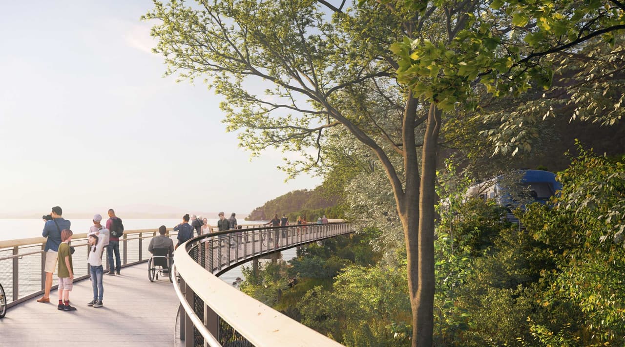
Artist's rendering of the proposed elevated shoreline trail: a broad timber-decked walkway on a gentle curve above the water, with a cable-and-post rail on the river side. Twenty or so people are spread along it: a family with two children in the foreground, a person using a manual wheelchair stopped facing the view, walkers, and a cyclist further along the curve. Mature trees lean over the deck from the landward side.
Artist's rendering — not a photograph · SCAPE / HHFT Artist's rendering — the proposed elevated shoreline trail. Not built.

Construction progress →

Connecting trails

14 state-park trails

Hudson Highlands State Park Preserve, inside the corridor
Trail Blaze Grade Miles
Wilkinson Memorial Trail Yellow strenuous 7.8
Highlands Trail Teal varies 7.1
Breakneck Ridge Trail White very strenuous 4.8
Fishkill Ridge Trail White strenuous 4.5

Steep, unpaved, not step-free

Where the blaze colours and grades came from

Geometry © OpenStreetMap contributors (ODbL). Blaze colours and difficulty ratings are editorial summaries from our own research, not sourced from NYS Parks or the NY–NJ Trail Conference. Lengths are the portion inside the study corridor, not the full trail. Breakneck Ridge is a strenuous rock scramble with a significant rescue history.

All 14 trails →

Take it with you

No signal at the trailheads

cms-git · built 2026-08-09

Everything else on the map

Meanders, shuttle stops and restrooms along the corridor. Sections, trailheads, car parks and stations are above.

  1. 0.0

    MNR Cold Spring train station

    Planned

    Shuttle stop

    Accessible shuttle. Service would start with the separate Dutchess Manor project and expand to Trail Corridor destinations as elements of the trail are completed and demand warrants.

    Facilities at MNR Cold Spring train station
    Lighting Not recorded
    Surveyed on Never — the trail is not built
    Service planned
    Position: OpenStreetMap
  2. 0.1

    Proposed restrooms - Dockside Park

    Planned

    Restrooms

    up to 8 toilets per entry point, possibly in two ~400-500 sq ft buildings

    Facilities at Proposed restrooms - Dockside Park
    Lighting Not recorded
    Notes Location indicative — the FGEIS states specific locations are to be determined.
    Surveyed on Never — the trail is not built
    Position: Modelled from elevation data
  3. 0.1 to 0.3

    Meander — River Reach (7)

    Planned

    Meander · 0.23 mi

    Facilities at Meander — River Reach (7)
    Width 4-8 ft
    Permitted Walking only — no bikes
    Slope No slope data. The elevation sampling covered the Main Trail and the connectors; the meanders were not included.
    Surveyed on Never — the trail is not built
    Details
    Position: Traced from published planning figures
  4. 0.3 to 0.4

    Meander — River Reach (8)

    Planned

    Meander · 0.14 mi

    Facilities at Meander — River Reach (8)
    Width 4-8 ft
    Permitted Walking only — no bikes
    Slope No slope data. The elevation sampling covered the Main Trail and the connectors; the meanders were not included.
    Surveyed on Never — the trail is not built
    Details
    Position: Traced from published planning figures
  5. 0.4 to 0.5

    Meander — River Reach (12)

    Planned

    Meander · 0.10 mi

    Facilities at Meander — River Reach (12)
    Width 4-8 ft
    Permitted Walking only — no bikes
    Slope No slope data. The elevation sampling covered the Main Trail and the connectors; the meanders were not included.
    Surveyed on Never — the trail is not built
    Details
    Position: Traced from published planning figures
  6. 0.5 to 0.6

    Meander — River Reach (11)

    Planned

    Meander · 0.11 mi

    Facilities at Meander — River Reach (11)
    Width 4-8 ft
    Permitted Walking only — no bikes
    Slope No slope data. The elevation sampling covered the Main Trail and the connectors; the meanders were not included.
    Surveyed on Never — the trail is not built
    Details
    Position: Traced from published planning figures
  7. Meander · 112 ft

    Facilities at Meander — River Reach (16)
    Width 4-8 ft
    Permitted Walking only — no bikes
    Slope No slope data. The elevation sampling covered the Main Trail and the connectors; the meanders were not included.
    Surveyed on Never — the trail is not built
    Details
    Position: Traced from published planning figures
  8. 0.6 to 0.7

    Meander — River Reach (10)

    Planned

    Meander · 0.11 mi

    Facilities at Meander — River Reach (10)
    Width 4-8 ft
    Permitted Walking only — no bikes
    Slope No slope data. The elevation sampling covered the Main Trail and the connectors; the meanders were not included.
    Surveyed on Never — the trail is not built
    Details
    Position: Traced from published planning figures
  9. Meander · 75 ft

    Facilities at Meander — River Reach (17)
    Width 4-8 ft
    Permitted Walking only — no bikes
    Slope No slope data. The elevation sampling covered the Main Trail and the connectors; the meanders were not included.
    Surveyed on Never — the trail is not built
    Details
    Position: Traced from published planning figures
  10. 0.7 to 0.8

    Meander — River Reach (6)

    Planned

    Meander · 0.40 mi

    Facilities at Meander — River Reach (6)
    Width 4-8 ft
    Permitted Walking only — no bikes
    Slope No slope data. The elevation sampling covered the Main Trail and the connectors; the meanders were not included.
    Surveyed on Never — the trail is not built
    Details
    Position: Traced from published planning figures
  11. 0.7

    Proposed restrooms - Little Stony Point

    Planned

    Restrooms

    up to 8 toilets per entry point, possibly in two ~400-500 sq ft buildings

    Facilities at Proposed restrooms - Little Stony Point
    Lighting Not recorded
    Notes Location indicative — the FGEIS states specific locations are to be determined.
    Surveyed on Never — the trail is not built
    Position: Modelled from elevation data
  12. 0.7

    Meander — River Reach (9)

    Planned

    Meander · 0.12 mi

    Facilities at Meander — River Reach (9)
    Width 4-8 ft
    Permitted Walking only — no bikes
    Slope No slope data. The elevation sampling covered the Main Trail and the connectors; the meanders were not included.
    Surveyed on Never — the trail is not built
    Details
    Position: Traced from published planning figures
  13. 0.7

    Little Stony Point / Washburn Trailhead

    Planned

    Shuttle stop

    Accessible shuttle. Service would start with the separate Dutchess Manor project and expand to Trail Corridor destinations as elements of the trail are completed and demand warrants.

    Facilities at Little Stony Point / Washburn Trailhead
    Lighting Not recorded
    Surveyed on Never — the trail is not built
    Service planned
    Position: OpenStreetMap
  14. Meander · 190 ft

    Facilities at Meander — River Reach (14)
    Width 4-8 ft
    Permitted Walking only — no bikes
    Slope No slope data. The elevation sampling covered the Main Trail and the connectors; the meanders were not included.
    Surveyed on Never — the trail is not built
    Details
    Position: Traced from published planning figures
  15. Meander · 69 ft

    Facilities at Meander — River Reach (18)
    Width 4-8 ft
    Permitted Walking only — no bikes
    Slope No slope data. The elevation sampling covered the Main Trail and the connectors; the meanders were not included.
    Surveyed on Never — the trail is not built
    Details
    Position: Traced from published planning figures
  16. 2.6

    Breakneck Ridge

    Planned

    Shuttle stop

    Accessible shuttle. Service would start with the separate Dutchess Manor project and expand to Trail Corridor destinations as elements of the trail are completed and demand warrants.

    Facilities at Breakneck Ridge
    Lighting Not recorded
    Surveyed on Never — the trail is not built
    Service planned
    Position: OpenStreetMap
  17. Meander · 351 ft

    Facilities at Meander — Forest Trail South Reach (4)
    Width 4-8 ft
    Permitted Walking only — no bikes
    Slope No slope data. The elevation sampling covered the Main Trail and the connectors; the meanders were not included.
    Surveyed on Never — the trail is not built
    Details
    Position: Traced from published planning figures
  18. 3.6

    Dutchess Manor

    Planned

    Shuttle stop

    Accessible shuttle. Service would start with the separate Dutchess Manor project and expand to Trail Corridor destinations as elements of the trail are completed and demand warrants.

    Facilities at Dutchess Manor
    Lighting Not recorded
    Surveyed on Never — the trail is not built
    Service planned
    Position: Traced from published planning figures
  19. Meander · 0.30 mi

    Facilities at Meander — Forest Trail North Reach (2)
    Width 4-8 ft
    Permitted Walking only — no bikes
    Slope No slope data. The elevation sampling covered the Main Trail and the connectors; the meanders were not included.
    Surveyed on Never — the trail is not built
    Details
    Position: Traced from published planning figures
  20. 4.2

    Proposed restrooms - The Notch

    Planned

    Restrooms

    up to 8 toilets per entry point, possibly in two ~400-500 sq ft buildings

    Facilities at Proposed restrooms - The Notch
    Lighting Not recorded
    Notes Location indicative — the FGEIS states specific locations are to be determined.
    Surveyed on Never — the trail is not built
    Position: Modelled from elevation data
  21. 4.6

    The Notch

    Planned

    Shuttle stop

    Accessible shuttle. Service would start with the separate Dutchess Manor project and expand to Trail Corridor destinations as elements of the trail are completed and demand warrants.

    Facilities at The Notch
    Lighting Not recorded
    Surveyed on Never — the trail is not built
    Service planned
    Position: Traced from published planning figures
  22. Meander · 0.53 mi

    Facilities at Meander — Forest Trail North Reach (5)
    Width 4-8 ft
    Permitted Walking only — no bikes
    Slope No slope data. The elevation sampling covered the Main Trail and the connectors; the meanders were not included.
    Surveyed on Never — the trail is not built
    Details
    Position: Traced from published planning figures
  23. Meander · 141 ft

    Facilities at Meander — Forest Trail North Reach (15)
    Width 4-8 ft
    Permitted Walking only — no bikes
    Slope No slope data. The elevation sampling covered the Main Trail and the connectors; the meanders were not included.
    Surveyed on Never — the trail is not built
    Details
    Position: Traced from published planning figures
  24. 6.4 to 6.6

    Meander — Marsh Trail Reach (3)

    Planned

    Meander · 0.20 mi

    Facilities at Meander — Marsh Trail Reach (3)
    Width 4-8 ft
    Permitted Walking only — no bikes
    Slope No slope data. The elevation sampling covered the Main Trail and the connectors; the meanders were not included.
    Surveyed on Never — the trail is not built
    Details
    Position: Traced from published planning figures
  25. 6.5 to 6.6

    Meander — Marsh Trail Reach (13)

    Planned

    Meander · 331 ft

    Facilities at Meander — Marsh Trail Reach (13)
    Width 4-8 ft
    Permitted Walking only — no bikes
    Slope No slope data. The elevation sampling covered the Main Trail and the connectors; the meanders were not included.
    Surveyed on Never — the trail is not built
    Details
    Position: Traced from published planning figures
  26. 6.9 to 7.0

    Meander — Marsh Trail Reach (1)

    Planned

    Meander · 0.33 mi

    Facilities at Meander — Marsh Trail Reach (1)
    Width 4-8 ft
    Permitted Walking only — no bikes
    Slope No slope data. The elevation sampling covered the Main Trail and the connectors; the meanders were not included.
    Surveyed on Never — the trail is not built
    Details
    Position: Traced from published planning figures
  27. 6.9

    Proposed restrooms - Denning's Point

    Planned

    Restrooms

    up to 8 toilets per entry point, possibly in two ~400-500 sq ft buildings

    Facilities at Proposed restrooms - Denning's Point
    Lighting Not recorded
    Notes Location indicative — the FGEIS states specific locations are to be determined.
    Surveyed on Never — the trail is not built
    Position: Modelled from elevation data
  28. 7.1

    Proposed Maintenance Facility

    Planned

    Facility

    Facilities at Proposed Maintenance Facility
    Lighting Not recorded
    Notes Location indicative — the FGEIS states specific locations are to be determined.
    Surveyed on Never — the trail is not built
    Position: Traced from published planning figures
  29. 7.5

    Beacon Housing Authority

    Planned

    Shuttle stop

    Accessible shuttle. Service would start with the separate Dutchess Manor project and expand to Trail Corridor destinations as elements of the trail are completed and demand warrants.

    Facilities at Beacon Housing Authority
    Lighting Not recorded
    Surveyed on Never — the trail is not built
    Service planned
    Position: OpenStreetMap
  30. 7.7

    Long Dock Park

    Planned

    Shuttle stop

    Accessible shuttle. Service would start with the separate Dutchess Manor project and expand to Trail Corridor destinations as elements of the trail are completed and demand warrants.

    Facilities at Long Dock Park
    Lighting Not recorded
    Surveyed on Never — the trail is not built
    Service planned
    Position: OpenStreetMap
  31. 7.8

    Proposed restrooms - Long Dock Park

    Planned

    Restrooms

    up to 8 toilets per entry point, possibly in two ~400-500 sq ft buildings

    Facilities at Proposed restrooms - Long Dock Park
    Lighting Not recorded
    Notes Location indicative — the FGEIS states specific locations are to be determined.
    Surveyed on Never — the trail is not built
    Position: Modelled from elevation data
  32. 7.8

    MNR Beacon train station

    Planned

    Shuttle stop

    Accessible shuttle. Service would start with the separate Dutchess Manor project and expand to Trail Corridor destinations as elements of the trail are completed and demand warrants.

    Facilities at MNR Beacon train station
    Lighting Not recorded
    Surveyed on Never — the trail is not built
    Service planned
    Position: OpenStreetMap

Nearby, but not on the trail corridor

These are more than three quarters of a mile from the alignment, so a milepost would be misleading. They are here because visitors use them.

  1. About 2.5 miles from the trail

    Garrison

    Open

    Train station

    Metro-North Hudson Line.

    Facilities at Garrison
    Lighting Not recorded
    Surveyed on Never — the trail is not built
    Service in service
    Position: Published by the operator
  2. About 1.6 miles from the trail

    Mount Beacon

    Planned

    Shuttle stop

    Accessible shuttle. Service would start with the separate Dutchess Manor project and expand to Trail Corridor destinations as elements of the trail are completed and demand warrants.

    Facilities at Mount Beacon
    Lighting Not recorded
    Surveyed on Never — the trail is not built
    Service planned
    Position: Traced from published planning figures

Legend

What the drawing means
  • OPEN conifer, solid
  • BUILDING ochre rungs
  • PLANNED dashed
  • NOT DRAWN dotted, thin
  • CLOSED carmine hatch
  • SECTION END paper node
  • TRAILHEAD blaze pin
  • PARKING car pin
  • STATION slate square
  • RESTROOM slate dot
  • PARK TRAIL conifer, dashed
  • YOU ringed dot
  • WOODS flat wash
  • CAR PARK outlined wash
The four rows that need a sentence

NOT DRAWN — A straight line joining two real endpoints. No alignment has been published for these sections, so the drawing stops where our knowledge does.

CLOSED — Hatched under the line, with a ✕ at each end of the closed extent and a carmine bar on the mile rail. Four encodings, never colour alone.

PARK TRAIL — Existing Hudson Highlands State Park Preserve trails — open and hikable today, so they are drawn in conifer, the colour this map reserves for what is open now. The dash and thinner weight say they are not the Fjord Trail.

CAR PARK — Indicative footprint. The FGEIS says specific parking locations are to be determined.

Layers

Layer filters need JavaScript. Every layer is shown below.
Map settings

Keyboard controls
Arrows
Move the map
Shift + arrows
Move a whole screen
+ / −
Zoom
[ and ]
Previous / next place along the trail
Enter or i
Read the nearest place
Home
Whole corridor
Escape
Leave the map